Failed to execute CGI : Win32 Error Code = 2
Failed to execute CGI : Win32 Error Code = 2
Flight Explorer Study of Air Traffic Over Parsonsfield, Maine on a Monday Between 12 Noon and 1 PM
Flight Explorer Study of Air Traffic
Over Parsonsfield, Maine on a Monday Between 12 Noon and 1 PM
By Jay Reynolds and "Chickiedeb"
5/2/01
These images display commercial high altitude
traffic over Maine and New Hampshire captured by Flight
Explorer software. Full image screen captures can be accessed
by clicking the links above each image. These images were captured
on Monday, April 16, 2001 between 11am and 1:30 PM in order to
determine the extent of traffic normally seen on a day and time
similar to Tiffany Brendt's reported 30 jets over Parsonsfield,
Maine on Monday, March 16, 2001.
Credit for capturing this information goes
to Ms.
Chickiedeb, who in 1999 believed in chemtrails, but has determined
after over one year monitoring normal commercial traffic over
her area, using Flight Explorer, that what she believed were "chemtrails"
are nothing more than normal contrails.
The monitoring of these flights was very
difficult due to the large number of flights passing over this
small area, and the speed at which they traveled. Maximum traffic
did peak between 12 noon and 1 pm. During this period, as many
flights as possible were "tagged" or labeled to reveal
all identification possible. Some flights, about which information
could have been gathered, did not get tagged due to time constraints
and screen space used up by the tags.
Over ten captures were taken per hour and
saved, however, which identified
during the 12-1pm time period 20 flights. Between 11:27 and 1:30,
42 flights were observed.
Ms. Chickiedeb was faced with the multi-tasking
job of observing the flights, tagging them, and saving the screen
captures in another program, including typing file names for each
capture. It was hectic, trying, and difficult, despite her many
months experience using Flight Explorer, due to the intensity
of traffic there.
While traffic positively identified directly
over Parsonsfield on the day of this study was 20 planes rather
than the 30 planes described by Brendt, due to changing weather
conditions and North Atlantic Track conditions, flights could
be timed differently and follow different courses from day to
day. In fact, on some days perhaps even more or much less than
30 aircraft might be passing over this area, or another part of
the state.
This study proves that either Brendt and
Thomas were either unaware that normal commercial traffic is extensive
over the area, or chose to deliberately mislead readers and listeners
by making the false statement:
" No, not where we are, we’re not under
a major flight path."
During a telephone call with
Tiffany Brendt on April 29th, 2001, she admitted to me that she
had never seen an aeronautical chart of her area.
William Thomas and all other contrail
researchers have been aware of the utility of Flight Explorer
as a means to identify aircraft since I suggested this tool in
the summer of 1999. Their reluctance to even mention it shows
that they are aware that it will remove the mystery about contrails,
and allow their current followers to see that the normal contrails
they observe come
overwhelmingly from normal commercial aircraft, and are ordinary.
In effect, Flight Explorer is the
Sword of Damocles hanging over the "chemtrails" hoax,
poised, suspended by a mere thread, and able to destroy the lie
by revealing the truth. To ignore this tool is to deliberately
remain ignorant, and to deceive others as well.
http://worldzone.net/international/chickiedeb/cgi/11AMedt416FE1.gif
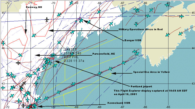
This view shows the general layout of the area in question.
Generally, flights arriving from Europe use a great circle route
which brings them across Nova Scotia heading towards either the
Bangor or Kennebunk Maine VOR radio navigation beacons. The flights
which pass over the Bangor VOR are usually the ones which are
visible from Parsonsfield, though contrails should be visible
for at least fifty miles. Note that the distance between Parsonsfield
and the Portland Jetport is about 30 miles. One degree latitude/longitude
equals approximately 69 statute miles.
Screen capture at 11:02 am:
http://worldzone.net/international/chickiedeb/cgi/11AMedt416FE2.gif
Screen capture at 11:07 am:
http://worldzone.net/international/chickiedeb/cgi/11AMedt416FE3.gif
Screen capture at 11:10 am:
http://worldzone.net/international/chickiedeb/cgi/11AMedt416FE4.gif
Screen capture at 11:20 am:
http://worldzone.net/international/chickiedeb/cgi/11AMedtFE4165.gif
Screen capture at 11:27 am:
http://worldzone.net/international/chickiedeb/cgi/11AMedt416FE6.gif
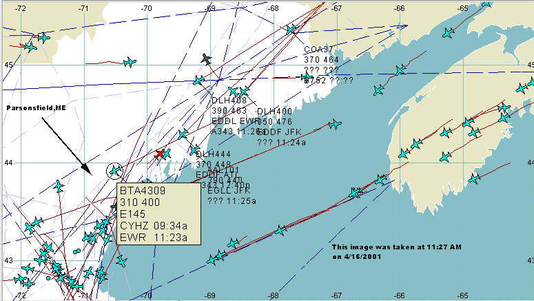
At 11: 30 am, international flights are beginning to overfly the
Parsonsfield area, led by British Airways(BTA) flight 4309, flying
at 31,000 ft(310) at 400 knots, departed Halifax, Nova Scotia(CYHZ)
at 9:34 am, arrives Newark, NJ(EWR) at 11:23 am. Also 3 Lufthansa(DLH)
flights- 400-408-444 which departed from Frankfurt(EDDF) and Dusseldorf(EDDL),
American Airlines(AAL) from Heathrow(EGLL) to JFK, and Continental
Airlines(COA) Flight 37.
Screen capture at 11:32 am:
http://worldzone.net/international/chickiedeb/cgi/11AMedt416FE7.gif
Screen capture at 11:35 am:
http://worldzone.net/international/chickiedeb/cgi/11AMedt416FE8.gif
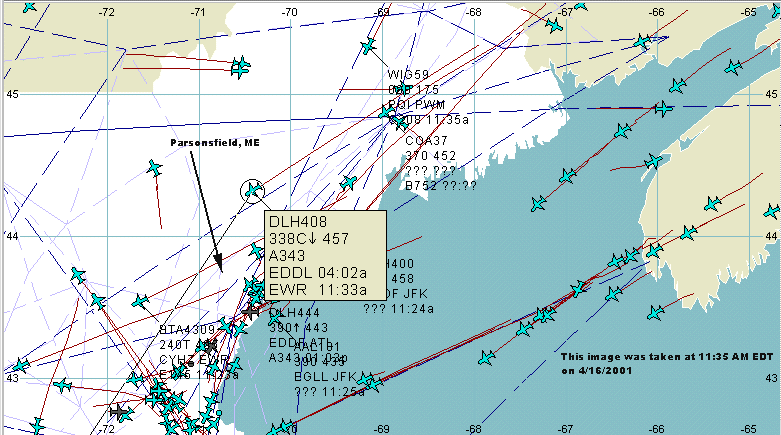
The Lufthansa(DLH) flights are now overflying the Parsonsfield
area. Several other flights can be seen leaving the Kennebunk
VOR flying NNW, and visible to the east of Parsonsfield.
HERE'S WHERE THE FUN BEGINS:
Screen capture at 11:37am:
http://worldzone.net/international/chickiedeb/cgi/1130AMedt416FE1.gif
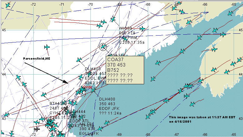
Continental Airlines flight 37 is at 37,000 ft. flying at 453
knots. It is a Boeing
757-200 and according to Continental
Airlines, flies from Dusseldorf to Newark and continues on
to San Francisco.
Screen capture at 11:42 am:
http://worldzone.net/international/chickiedeb/cgi/1130AMedt416FE1a.gif
Screen capture at 11:43 am:
http://worldzone.net/international/chickiedeb/cgi/1130AMedt416FE1b.gif
Screen capture at 11:51 am:
http://worldzone.net/international/chickiedeb/cgi/1145AMedt416FE1.gif
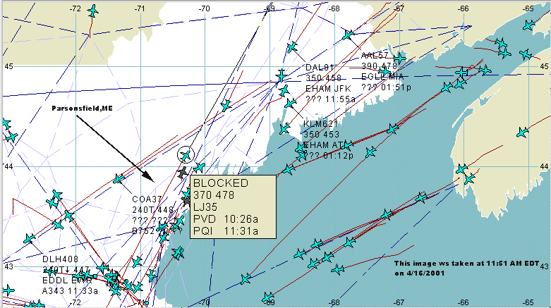
Passing just NE of Parsonsfield is an example of a flight whose
owner has requested it's identification be blocked on Flight Explorer.
We can tell that it is a Learjet 35(LJ35), is flying at 37,000
ft(370) at 478 knots, departed Providence, RI(PVD) at 10:26, and
should arrive at Presque Isle, Maine(PQI) at 11:31. It appears
to be 20 minutes late.
Screen capture at 12:00 PM:
http://worldzone.net/international/chickiedeb/cgi/12PMedt416FE.gif
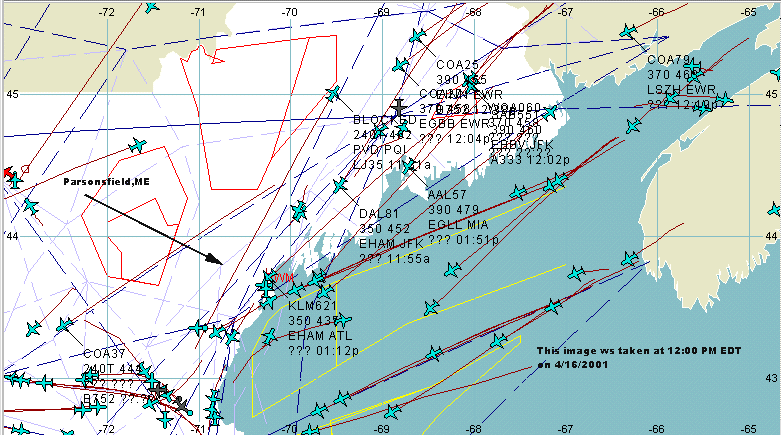
Now entering the airspace over Parsonsfield is Delta Airlines(DAL)
Flight 81 at 35,000 ft and 452 knots, departed Schipol, Netherlands(EHAM)
heading for JFK. Approaching is American Airlines Flight 57 at
39,000 ft and 479 knots from Heathrow(EGLL) to Miami.
Screen capture at 12:07PM:
http://worldzone.net/international/chickiedeb/cgi/12PMedt416FE1.gif
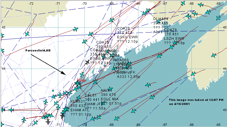
Approaching Parsonsfield are three Continental Airlines flights,
COA #'s 25, 27, and 29, which departed Shannon, Ireland(EINN),
Birmingham,England(EGBB), and Gatwick, England(EGKK),
headed for Newark and JFK. Also approaching is World Airways(WOA)
Flight 060.
Screen capture at 12:13 PM:
http://worldzone.net/international/chickiedeb/cgi/12PMedt416FE2.gif
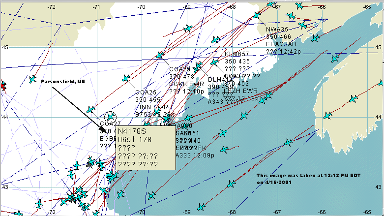
Passing over Parsonsfield at 6500 ft is a 1975 Beechcraft
58 owned by Glad Aviation of Gilford, NH.. Continental Flight
27 is directly over Parsonsfield.
Screen capture at 12:21 PM:
http://worldzone.net/international/chickiedeb/cgi/12PMedt416FE3.gif
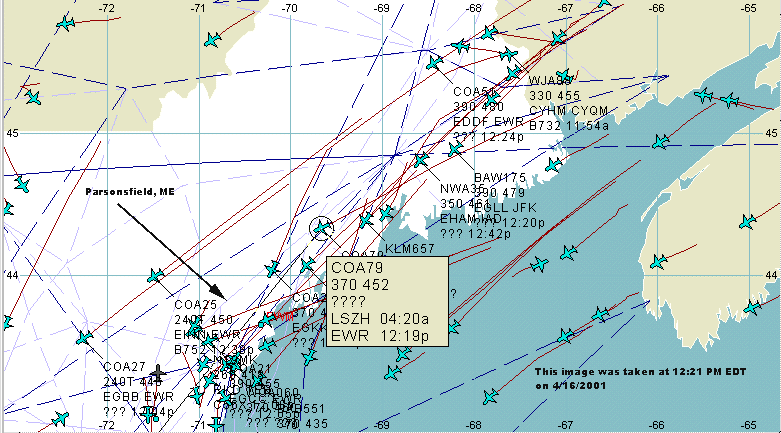
Approaching Parsonsfield is Continental Flight 79 from Zurich(LSZH)
to Newark.
Screen capture at 12:26:
http://worldzone.net/international/chickiedeb/cgi/12PMedt416FE4.gif
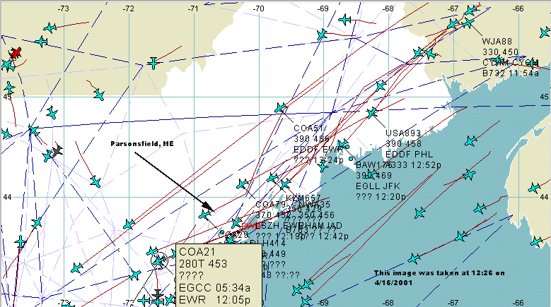
Now passing Parsonsfield is Continental Flight 21 at 28,000ft
from Manchester, England(EGCC) to Newark, closely followed by
Royal Dutch Airlines(KLM) flight 657 at 35,000 ft.
Screen capture at 12:29:
http://worldzone.net/international/chickiedeb/cgi/12PMedt416FE5.gif
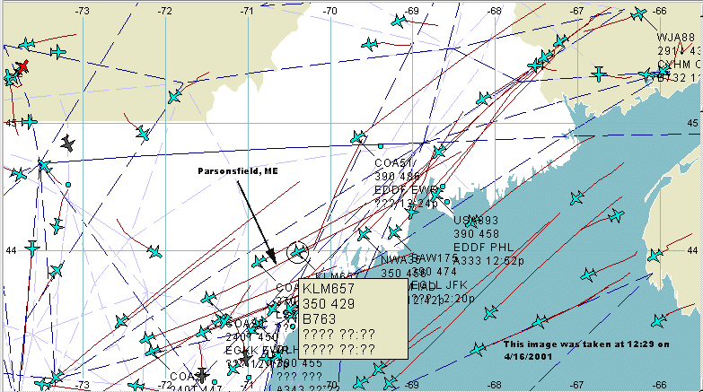
Approaching Parsonsfield are British Airways Flight 175 at
39,000 ft and 474 knots, departed Heathrow, England(EGLL) destination
JFK, followed by US Air Flight 893 at 39,000 ft and 458 knots,
departed Frankfurt, Germany(EDDF) destined for Philadelphia.
Screen capture at 12:32 pm:
http://worldzone.net/international/chickiedeb/cgi/12PMedt416FE6.gif
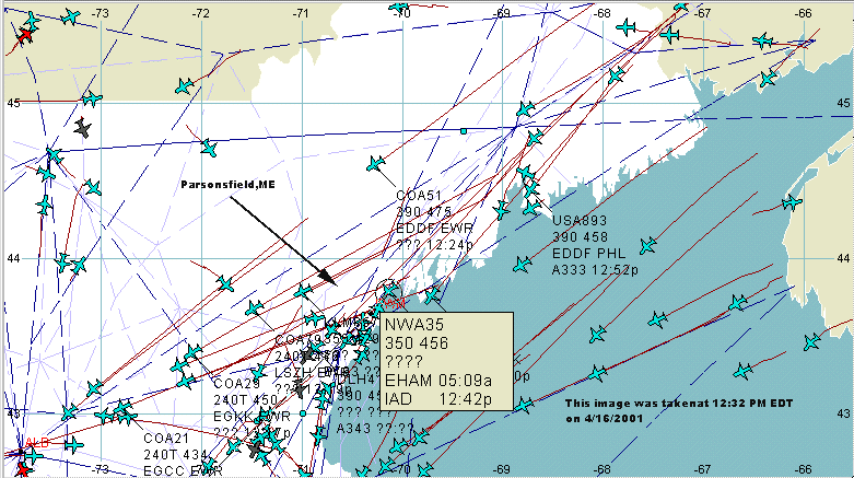
Passing over Parsonsfield is Northwest Airlines Flight 35 at
35,000 feet and 456 knots, departed Schipol, Netherlands(EHAM),
bound for Washington Dulles Airport. Approaching Parsonsfield
is Continental Airlines Flight 51, departed Frankfurt, Germany(EDDF),
heading to Newark, NJ(EWR).
Screen capture at 12:35 PM:
http://worldzone.net/international/chickiedeb/cgi/12PMedt416FE7.gif
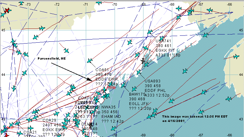
approaching Parsonsfield are US Air Flights 893 and 741, both
at 39,000 ft, departed Frankfurt(EDFF) and Gatwick(EGKK) headed
for Philadelphia and Pittsburgh.
Screen capture at 12:40 PM:
http://worldzone.net/international/chickiedeb/cgi/12PMedt416FE8.gif
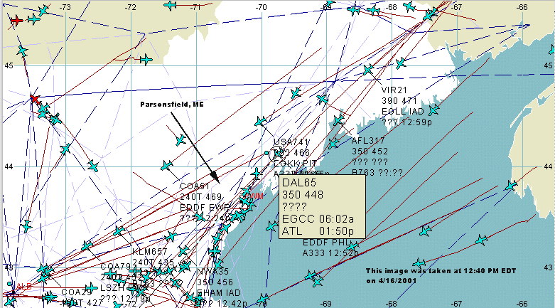
Just north of Parsonsfield is Delta Airlines Flight 65 at 35,000
ft and 448 knots, departed Manchester, England(EGCC) destination
Atlanta. North is Aeroflot Flight 317 at 35,800 ft and 452 knots.
Screen capture at 12:47 PM:
http://worldzone.net/international/chickiedeb/cgi/12PMedt416FE9.gif
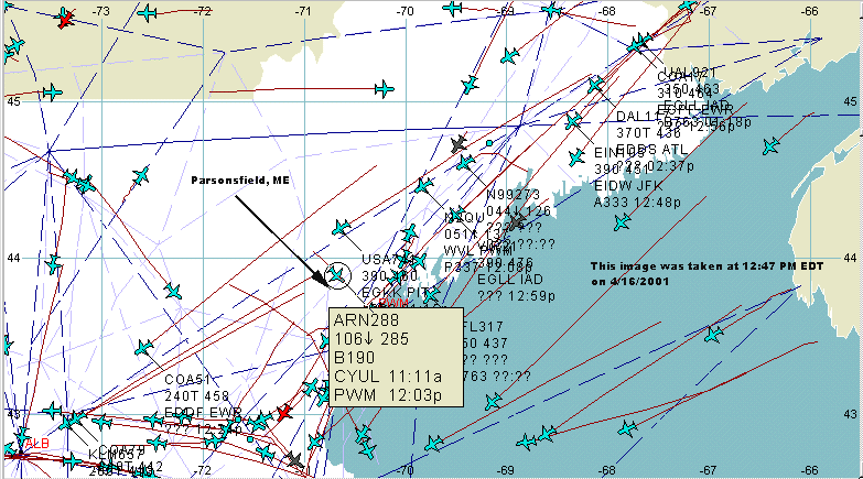
Passing over Parsonsfield is Air Ontario Flight 288 at 10,600
ft, descending , departed Montreal Dorval(CYUL) on approach to
Portland, Maine(PWM).
Screen capture at 12:49 PM:
http://worldzone.net/international/chickiedeb/cgi/12PMedt416FE10.gif
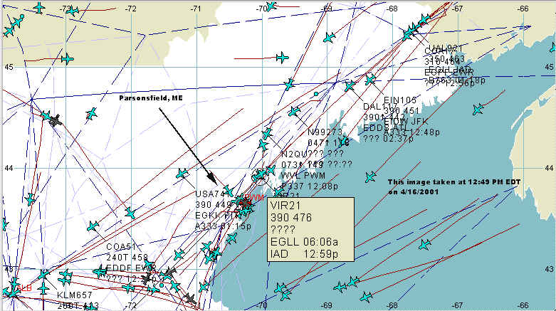
Passing over Parsonsfield is Virgin Atlantic Airways Flight
21, departed Heathrow(EGLL), bound for Dulles International. This
is the same airline whose planes feature red engine cowlings and
tail colors shown on the previous page of this report. It is followed
by Aer Lingus Flight 105 departed Dublin, Ireland bound for JFK.
Screen capture at 1:02 PM
http://worldzone.net/international/chickiedeb/cgi/1PMedt416FEmess.gif
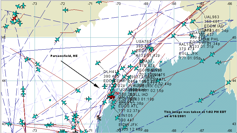
Passing just north of Parsonsfield is Lufthansa Flight 410
departed Dusseldorf(EDDL) bound for Newark. it is followed by
Continental Airlines Flight 17 departed Dyce, England, and USAir
Flight 781 from Frankfurt, Germany(EDDF). At this point, and in
the following images, so many flights are passing at the same
time that the flight tags are becoming unreadable due to their
density. It is possible to turn them off, but they come so fast
it is difficult to keep up, and capture the screen on disk at
the same time.
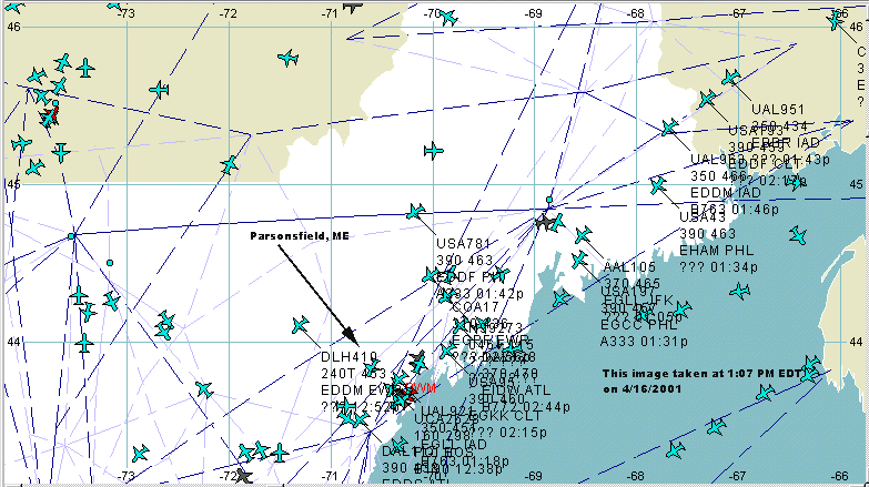
Screen capture at 1:07 PM:
http://worldzone.net/international/chickiedeb/cgi/1PMedt416FE11.gif
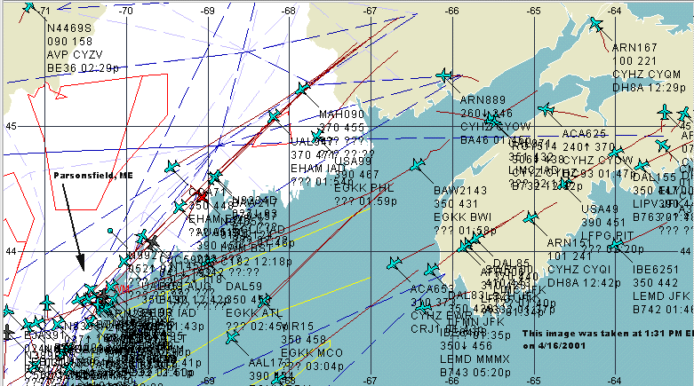
Screen capture at 1:31 PM:
http://worldzone.net/international/chickiedeb/cgi/1PMedt416FEalltags.gif
http://worldzone.net/international/chickiedeb/cgi/1PMedt416FEmess2.gif
http://worldzone.net/international/chickiedeb/cgi/1PMedt416FEmess3.gif
Back to Contrails over the Northeastern US -


March 12, 2001
Back to Contrails- or Trails-Con?

